Beaumaris to Llanddona – Wales Coast Path

« of 2 »

Our motto for the walk from Macbeth, much quoted by Lucy “I am in blood stepped in so far that should I wade no more, Returning were as tedious as go o’er,”

Here we are at last, the final day’s walking on the Wales Coast Path. We were up early only to be greeted by a dense sea fog. By the time we positioned our cars and set off along the promenade in Beaumaris, there was enough visibility to walk, but not to see the glorious views across the bay.

Beaumaris Castle was a vague, ghostly outline in the distance. From the promenade we entered a kissing gate which led us up through a grassy field. We stopped to talk to a chap who was hoping for the fog to lift. We told him that by the end of the day we would have walked the 870 miles of the Wales Coast Path. He was full of admiration and wanted to know what charity we were supporting so he could donate. Several people had offered to donate to a charity of our choice enroute but we hadn’t really considered the option.

Once off the grassy path we followed the road clearly signposted – onto a concrete wall then a shingle beach, we tried to find some sandy bits as the shingle was hard work. Tip toeing along in the mist, we must have been a sorry sight should anybody be looking out from the houses as we scrunched our way along delicately.

Along the cliff face caves appear to have been dug out, while one boulder looks like an ugly giant’s face, alongside an isolated rock formation.

Before we are forced off the beach by a river running through, we stop to take in the big reveal. The mist has lifted a little and we get a brief view of Snowdonia in the distance. Tantalising!
We head inland following the signs to steps, another shingle beach and yet another long stretch by road to the 11th Century Penmon Priory, with it’s distinctive Dovecote which dates from the 16th century.

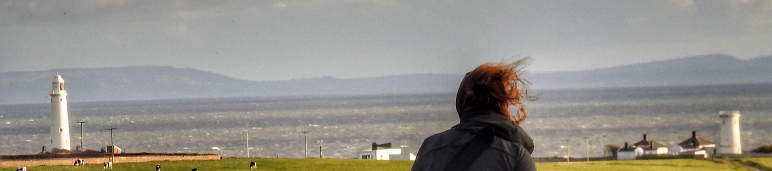
Exiting through the Toll Gate we make good time to Trwyn Du and the Penmon Lighthouse. Still draped in mist, we couldn’t see across to Puffin island let alone Llandudno and the Isle of Man. My hair is damp from the clinging mist.

The camper vans parked here for the night we’re getting ready to set off for the day, while we made our way to the whitewashed cafe for a cuppa.

The WCP turns left just before the car park here entering into an area covered by bushes, clearly signposted until you reach a long whitish wall. Continuing until we passed a corner of a house, we are signpost downhill.

From here we lost track of directions, just following the route around and between whitewashed houses, over narrow roads and wooded track to Glan-yr-Afon.

We were reminiscing about our walk so much we must have missed a sign, as the guidebooks talk about Llanfihangel Chapel while we found ourselves at Llanfihangel School, but we soon picked up the working farm which was mentioned in the guide books.

Blimey, I must have been tired as I left my camera on the wall here while I checked on our onward journey. Soon spotted, I raced back to collect it, the camera has been like an additional limb through this adventure.

Lots of work taking place on the path here, so the guidebooks don’t follow the new layout. There is still a steep descent down some steps though, and while we had rather hoped that we would end our 870 mile walk with stunning views across to Red Wharf Bay and Llanddona Beach, but that weird sea mist was still hanging around.

Down on the beach we found a local fisherman who was happy to take our photo, before we jumped in the car for taking on that testing road up to Llanddona village and home.

Llanddona to Dulas – Wales Coast Path

« of 2 »

As I drive down to Llanddona beach from the village I hold my breath. The road is winding, narrow and steep.  It was a relief to reach the car park as our friend Esther drives up in her distinctive VW beetle.

It is early morning and promises to be a glorious day.

The tide is out and we set off to walk as far as we could along the beach, before heading back to the sign posted path over the marshes. This is a glorious curve of coast to Red Wharf Bay and most of it follows the shore line. Over the little bridge we go before rounding the curve and stopping off for coffee at The Ship Inn, already very busy despite the early hour.

For some reason whenever I pronounced Red Wharf Bay it came out as Red Dwarf Bay and so it shall be forever more. Passing by the car park, we continued to the end of the road where the signpost takes us up the hill through a caravan park, towards the end of the site forking off to the right of the main road we missed a low level sign, and found ourselves in a new luxury chalet development called the View, which we didn’t have time to enjoy, as realising our mistake we retraced our steps downhill.

For the first time in months we feel hot under the noon day sun – just saying, not complaining. We reach the wooded path with glimpses of clear blue sea, large limestone quarry face tower above us on the left of the path.  We step onto the road at Benllech and stop for our picnic lunch on the benches facing the beach.  Families are out enjoying the early May bank holiday sun.

We gather ourselves and reach another caravan park, following the diversion signs, apparently there had been a significant cliff fall. I think we would still be wandering around the park if it wasn’t for a very kind chap popping out of his caravan and showing us the way onwards – the signs are pretty discreet to say the least.

A very relaxing walk onwards through Traeth Bychan and Penrhyn Point follows, with crystal clear blue water on our right.

Moelfre was to be our next stop – tea and cake at Ann’s Pantry beckoned.  A group of ladies were opening their fourth bottle of prosseco, I was envious!

We walked across the front up to the Wool shop that Esther used to go to as a child, holidaying with her aunt. Happy memories. Passing below the commemorative statue to coxswain, Richard “Dic” Evans awarded the RNLI gold medal, having served on 179 launches and saved 280 lives.

After the lifeboat station we covered some ground across the cliff tops, stopping to take in the Royal Charter Memorial just above the path. This clipper was on the last leg of its journey from Melbourne to Liverpool in October 1859 when it went aground. 460 lives were lost along with the cargo in a hurricane force 12 storm.  There was a great deal of gold on board, and the largest gold nugget found on Anglesey was discovered as late as 2012.

An easy walk to yet another sandy  beach at  Traeth Lligwy  with  the car park packed with camper vans, through the  sandy dunes over a footbridge to another car park, follow the signs to reach Traeth yr Ora, where you can go down to the beach but the path turns inland.

We then followed the path inland for quite a long stretch before  eventually reaching a small pond, continuing to the right of the pond we made our way wearily to the Pilot Boat Inn on the A5025.

Dulas to Amlwch – Wales Coast Path

« of 2 »

Having lunched in Porth Amlwch after our morning walk from Dulas, we decide to drive to Cemaes and walk back to Porth Amlwch, mainly because we felt that  walking  towards the decommissioned Wylfa  Nuclear Power station might detract from the mood of the moment, also we wanted to leave the car in Cemaes ready for next day’s trek.

This turned out to be one of my favourite walks, in addition to the natural beauty, this stretch has a wealth of easy to access heritage sites.

We set off across the harbour stopping to take in the Tide and Time St Patrick’s Bell, before heading for the headland.

Reaching Porth Padrig beach, the rock formation Y Ladi Wen – the White Lady stands out against the backdrop of the golden cliffs. No wonder Anglesey is a joy for geologist field trips.  Hardly surprising that the island is part of the European Geoparks Network and the Global Geoparks Network.

We walked across the beach and scrambled up the other side.  Our next stop was the enchanting Llanbadrig Church. Named after St Patrick who is said to have been shipwrecked on the island. There has been a church on the site since 440AD. This simple church is a tranquil stop off point.

Climbing over the stile in the churchyard, I try and make out the hazy outline of the Isle of Man.
From here, the walk gets more strenuous, with steep steps to Porth Llanlleiana. The clay works here were built over a nunnery, and created porcelain until it closed in the 1920s.

We made a choice here to stick to the more strenuous route rather than divert to an easier stretch, and continued to Hell’s Mouth – Porth Cynfor, another steep descent and ascent!

Moving swiftly on, we were fascinated by the completeness of the Borth Wen brickworks, from the ruined winding gear on the hill to the chimneys and kilns. It also features a natural arch that looks like an elephant’s trunk.

From here there is a nice, easy section to Bull’s Bay, the rocks here are over 600 million years old, which is how old I am beginning to feel. We watch a group of rowers in the bay, before pushing on to Amlwch, and are happy to see the bromide extraction plant come into view.

A brilliant day’s walking.